by Zachary Singer, MHT Research Archaeologist, and the Staff of Applied Archaeology and History Associates, Inc.
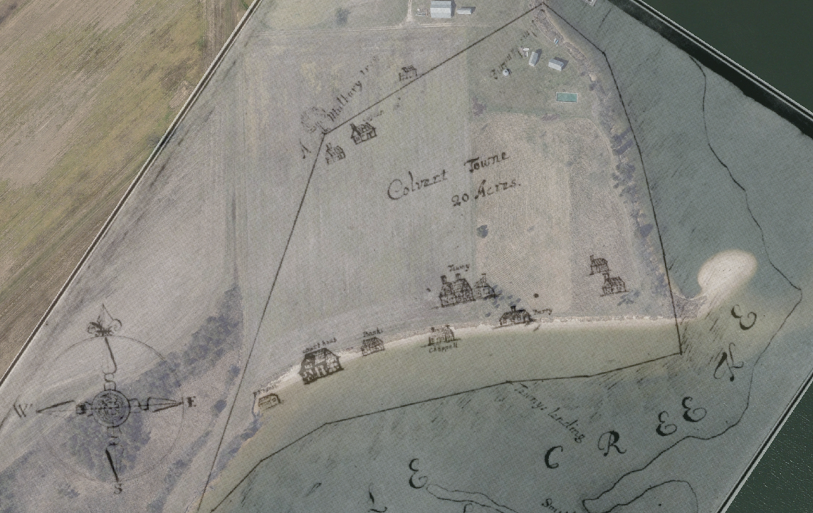
In addition to celebrating Maryland Archeology Month in April, Governor Larry Hogan proclaimed April 2021 as the first Maryland Flood Awareness Month. Although, April 2021 is the first official concurrent observance, 2017’s Archeology Month – At The Water’s Edge: Our Past on the Brink addressed the effects of flood hazards on archaeological sites. In the 2017 Archeology Month Booklet, Jason Tyler of Applied Archaeology and History Associates, Inc. (AAHA) contributed an essay entitled “A Return to Calverton, or What’s Left of It”. In the essay, Jason described the results of a 2015 survey to document archaeological resources along the banks of Battle Creek in Calvert County and highlighted the impacts of shoreline erosion on the late 17th-century Calverton site (18CV22). Calverton was laid out in 1668 and served as the seat of government within Calvert County from 1668-1725. Jason concluded the chapter by advocating to protect the site from erosion and flood hazards and also to document the site through archaeology to learn about the threatened cultural resources at Calverton.

The Calverton Shoreline, 1682 vs. Today
Following Jason’s recommendation, the 2017 and 2018 Tyler Bastian Field Sessions with the Archeological Society of Maryland were held at the Calverton site to investigate the site before storm-surge flooding and the wind-driven waters of Battle Creek further eroded what evidence remained of the town. The field sessions focused on ground-truthing anomalies identified during a magnetic susceptibility survey by the MHT Office of Archaeology. The Field Session investigations identified a part of the Colonial town that had not entirely washed into Battle Creek, including intact sub-plowzone cultural horizons and features. In the summer of 2020, AAHA conducted supplemental archaeological investigations at Calverton to continue documenting those portions of the site at heightened risk from shoreline erosion and flooding caused by sea level rise. The 2020 work was supported by the Calvert County Government and a grant from the Maryland Heritage Areas Authority.

Magnetic Susceptibility Data Collected by the MHT Office of Archaeology
Prior to AAHA’s 2020 field investigations, the MHT Office of Archaeology conducted a ground penetrating radar (GPR) survey within 10 meters of the eroding bank overhanging Battle Creek to identify anomalies in the area of the site most at risk to further loss from wind and water action. The GPR essentially uses a 350MHz (megahertz) antenna to send radio pulses into the ground which bounce off of subsurface anomalies and return to the antenna. Through the use of special software, the data collected by the GPR operator can be used to create a detailed 3 dimensional model (called a 3D time slice) that reveals both the horizontal and vertical relationships amongst radar anomalies including potential cultural features (trash pits, cellars, privies), potential modern disturbances, and natural tree root systems.


MHT archaeologists identified seven likely anthropogenic features via examination of the radar time slices. There were two large rectilinear anomalies in the eastern portion of the survey area. A deep, roughly circular anomaly near the center of the survey area was interpreted as a possible well. To the west of the possible well was an irregular anomaly that corresponded with a magnetic aberration identified during a 2019 gradiometer survey. To the east of the possible well was another amorphous anomaly. One trench-like linear anomaly was identified running roughly north-south in the western portion of the survey area. Additionally, one irregularly-shaped anomaly appeared in the southwest corner of the survey area and roughly corresponded to the location of a feature identified in 2017: a cluster of artifacts partly eroding from the bank of Battle Creek. In addition, the rectangular footprint of a test unit from previous excavations was identified, confirming the projection of these anomalies in real space. All seven potential cultural features were recommended for ground-truthing during AAHA’s 2020 archaeological fieldwork.
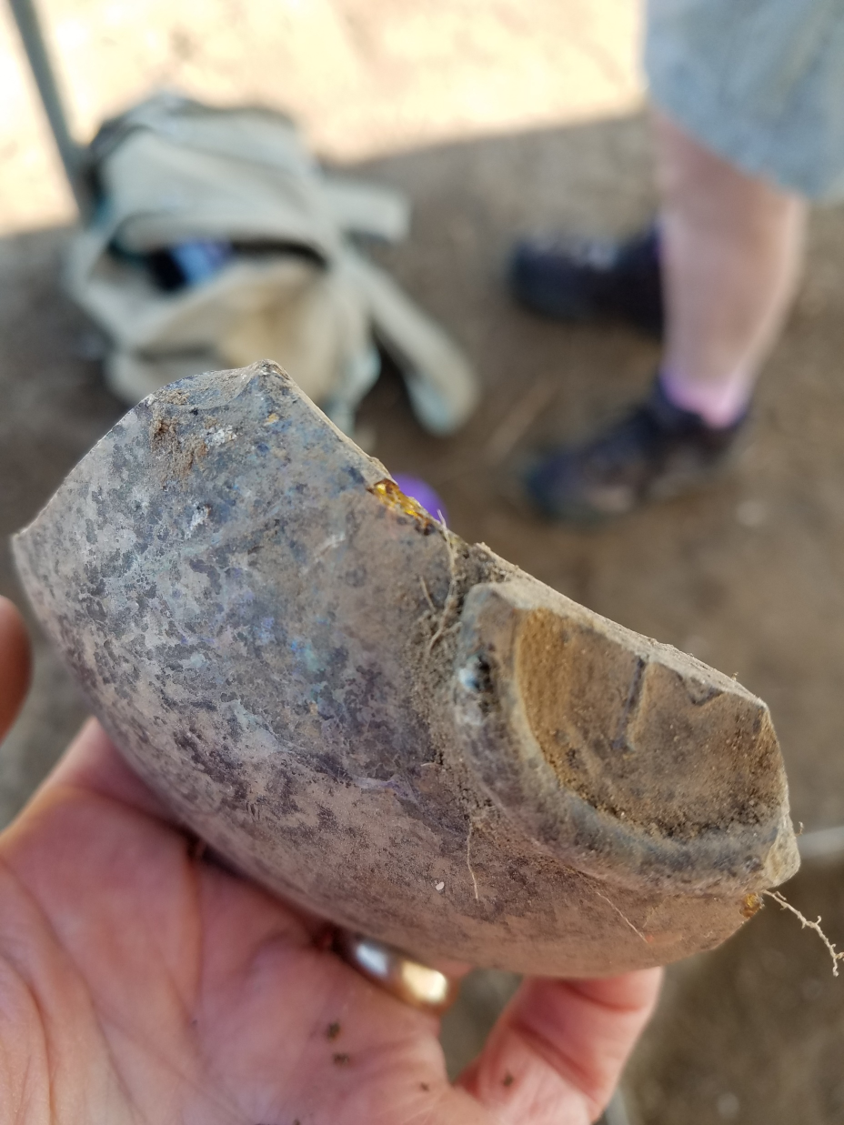
In total, AAHA excavated eight Test Units during the 2020 fieldwork to assess the form and function of the GPR anomalies. The excavations resulted in the identification of ten cultural features and the recovery of 3,369 artifacts mostly dating from the late 17th and early 18th century including tobacco pipes, a Charles I sixpence coin (1639-1645), and sherds of tin glazed earthenware. Of the ten features identified and excavated by AAHA in 2020, seven are related to the occupation of Calverton most likely from the late seventeenth century and the first quarter of the eighteenth century. The largest and most artifact-dense features related to the colonial occupation of Calverton were identified in the central portion of the study area and represent a posthole/mold (Feature 15/22), a small cellar (Feature 14 – the anomaly originally thought to be a possible well), and a possible trash pit (Features 16 and 17). Also identified was a small trench or ditch feature for what was probably once a paling fence in the western portion of the study area (Feature 19).


The 2020 archaeological investigation at Calverton provided additional data crucial to understanding the colonial occupation of the town in the portions of the site most vulnerable to flooding and erosion. Most significantly, it identified a previously unknown cellar (Feature 14) and an associated post hole/mold (Feature 15/22) both of which likely reflect the location of a colonial structure. While the small window into this structure excavated to-date has allowed some preliminary conclusions to be drawn, additional excavations could further reveal the size, layout, and function of the former building. Additional excavation and GPR survey in the vicinity of the paling trench identified during the 2020 investigation (Feature 19) could also provide valuable data on lot divisions in Calverton and colonial towns as a whole.
Another important aspect of the 2020 project was to monitor the shoreline at Calverton to continue assessing the risk of the site to the destructive power of wind and water action along Battle Creek, which remains an imminent threat to the archaeological resources at the site. MHT map projections show that the town’s important public buildings, including the courthouse and chapel, have already been lost to Battle Creek. AAHA’s comparison of the 2020 location of the Battle Creek bank to the location recorded by a 2017 Calvert County LiDAR survey shows shoreline loss ranging from 0.0313 meters to 3.204 meters, with an average of 1.333 meters of loss over two years, or 60- 70 centimeters per year. Most alarmingly, seven of the 28 points taken for the analysis (25% of the total) show shoreline loss in excess of 2 meters and these points occurred over the entire length of the surveyed shoreline. At this rate, the late 17th/early 18th-century cellar feature (Feature 14) will be lost to erosion by 2028 without intervention. With climate change comes increasing numbers of catastrophic storms. Tidal surges during such storm events can wreak havoc on the shoreline, severely undercutting the bank at Calverton.
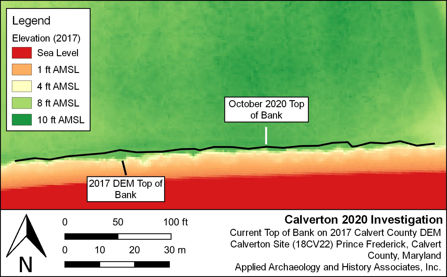
Map Depicting the Rate of Shoreline Loss at Calverton between 2017 and 2020
This reinforces the urgent need for additional archaeology at Calverton before the resource is entirely lost. Maryland Flood Awareness Month aligning with Maryland Archeology Month provides the perfect opportunity to discuss the impacts of flooding on archaeological resources. To learn more about planning efforts to protect archaeological sites from the impacts of flood hazards, please see the MHT’s guide for Planning for Maryland’s Flood-Prone Archeological Resources.